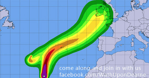
20180917-storm-helene.jpg
#wathupondearne
Latest news in Yorkshire: September 17, 2018 09:58:40 AM
MET Office public information release
Wind
Between 18:00 Mon 17 Sep and 08:00 Tue 18 Sep
Storm Helene will bring a spell of strong winds to western parts of the UK
in particular late Monday and early Tuesday.
What to expect
. Some delays to road, rail, air and ferry transport expected.
. Some bus and train services affected, with some journeys
taking longer.
. Delays for high-sided vehicles on exposed routes and bridges.
. Some short term loss of power and other services.
. Coastal routes, sea fronts and coastal communities affected by
spray and/or large waves.
. Some damage to trees is possible, for example large branches
or trees falling in a few places.
What should I do?
Further details
Storm Helene is expected to move northeastwards across the British Isles
later Monday and early Tuesday before clearing into the northern North Sea
by early Tuesday morning. A spell of strong winds is expected, initially
mainly in the far southwest of England and across western Wales. The
strongest winds then transfer northwards to be over northern England and,
perhaps, the far south of Scotland, during the early hours of Tuesday. Winds
are likely to gust into the 40s or low 50s mph quite widely across the
warning area. Meanwhile, in some Irish Sea coastal areas, most likely in
Wales and northwest England, gusts to 55-65 mph are likely with possible
isolated gusts in excess of 70 mph in the most exposed places. High gusts in
the 50s or low 60s mph area also possible over high ground in northern
England during the early hours of Tuesday.
See our yorkshire photography:
https://wath-on-dearne.com/wathondearne/around-the-dearne-valley/
News Source: Rotherham Advertiser – rotherhamadvertiser.co.uk
- The Manvers Wath-upon-Dearne
- A Level student Megan hits her target
- wathupondearne Latest news in Yorkshire: October 16, 2018 02:01:05 PM
- Five jailed for over 25-years for ‘horrific’ Doncaster attack
- Council rolls out more safety measures for schools
- Burman Road Tram Junction
- Childhood memories wanted
- Police op tackles drugs, weapons and badger baiting
- Hyperloop One to build super-fast underwater transport system
- South Anston post office robbery
- Man sentenced for hate crime in Rotherham
- Extra staff to tackle litter, dog fouling and illegal parking
- Modern day slavery, human trafficking and the signs to look out for
- Conisbrough Castle in South Yorkshire
- The American Bison Bison Bison!
- Wath Main Colliery 1910
- Success for Barnsley off-road bike operation
- Teachers from Norway visit Barnsley College
- One of the UK’s very best green spaces
- Barnsley officers take action against ‘cuckooing’
- Risks of taking antibiotics when you don’t need to
- Get your treasures valued at Clifton Park Museum
- Barnsley incident: woman remanded in custody
- Man charged with murder in Barnsley
- Appeal for information following armed robbery
- Burman Road in Wath-upon-Dearne
- Wath road closed due to “dangerous manhole covers”
- Convicted paedophile pleads guilty to further sex offences
- Man named in Sheffield murder inquiry
- Arrest after police helicopter targeted in Barnsley laser attack
- Hardship support for households from RMBC
- Register for priority services at Northern Powergrid
- Residents make Clifton Park a winner
- Road networks targeted by Op Voyager
- Charity’s plea to rescue centres
- CCTV released following firearms incident in Rossington
- Students experience life on the watch
- Renewed appeal following fatal collision, Barnsley
- APPEAL: Jewellery stolen from Doncaster burglary
- Cigarettes seized from Barnsley businesses
