20180914-storm-helena.jpg
#wathupondearne
Latest news in Yorkshire: September 14, 2018 02:42:31 PM
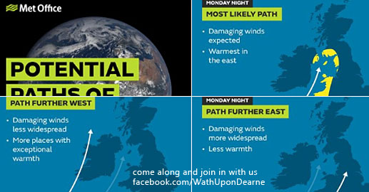
Tropical Storm Helene, which is currently in the mid-Atlantic, is expected
to track towards the UK over the next few days bringing a spell of windy
weather to many of us at the start of next week.
However as the storm travels across the Atlantic it will weaken, downgrading
from a tropical storm to an ex- tropical storm.
A Yellow National Severe Weather Warning has been issued for large parts of
the western UK as the storm is expected to affect the western side of the
country late on Monday, before clearing quickly to the north of Scotland
through Tuesday morning.
Met Office Chief Meteorologist, Andy Page said: “There remains large
uncertainty in the exact route Storm Helene will take, however, a spell of
very strong winds is expected, initially for parts of south-west England and
west Wales, then later south-west Scotland and the southeast of Northern
Ireland. Winds are likely to gust to 55-65 mph quite widely in the warning
area, with possible gusts of 70-80 mph in exposure”.
The storm will also bring some rain, the heaviest of which looks likely to
be restricted to the west side of the UK, as well as some warm tropical air,
meaning the south east of the country could see temperatures later in the
weekend and into the start of next week reaching the mid 20 Celsius.
Outside the warning area, there will be blustery conditions with increasing
amounts of cloud and rain. As Storm Helene clears, it will continue to be
windy with some bright or sunny spells.
See our yorkshire photography:
https://wath-on-dearne.com/wathondearne/around-the-dearne-valley/
- Apprentice Katie wins national award
- Get your treasures valued at Clifton Park Museum
- We should be able to vote aged 16, say Youth Cabinet
- BREAKING – Three arrested after police cars deliberately set alight
- Appeal for information following armed robbery
- Fined for using substitute meat in curry
- Introducing Funny Thursdays – April Fools Comedy Fest in Barnsley Markets!
- Investigation launched following discovery of man’s body, Barnsley
- Shisha users targeted in health campaign
- New Year, New Healthier You
- Rotherham is geared up for winter!
- Aston-cum-Aughton Leisure Centre celebrates 10th birthday
- Witnesses sought to Sheffield sexual assault
- Barnsley shop fined for selling out-of-date food
- E-fit released following attempted robbery in Walkley
- Saracens Head Church St 1991
- Wath-upon-Dearne Town End
- Horse Racing In Rotherham
- Closure orders stop neighbourhood ASB
- Old Church Mexborough South Yorkshire
- Week of action to tackle child criminal exploitation
- Plans to expand special school places agreed
- Three more prosecutions for Blue Badge abuse
- Two more years in jail for Sheffield child abuser
- E-fit released in connection to distraction burglary
- Lost Lander Finally Spotted on Comet’s Surface
- A VOLUNTEER SHOT
- Fly tippers issued with fixed penalty fines
- Rotherham Interchange to reopen after £12m refurbishment
- Strikes affect Northern and Southern Networks
- Two in court charged in connection to knife-related incidents, Sheffield
- Barnsley Sixth Form College celebrates 99% pass rate
- Armed robbery at South Anston Post Office
- Two jailed following burglary in Barnsley
- Black Rhino Project
- Hired by NCA to investigate child abuse scandal
- New rules for landlords come into force on Monday – RMBC reminder
- Officers welcome new recruits with a difference into SYP
- Community Speed Watch relaunched following requests from the public
- Modern slaves’ held at Barnsley hand car wash